Sea Surface Temperature (ENSO)
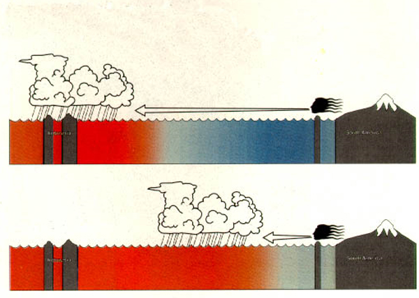
ENSO stands for “El Niño/Southern Oscillation”. ENSO involves irregular warming and cooling of the equatorial Pacific Ocean that influences tropical wind and rain. Understanding the different phases of ENSO (La Niña, Neutral, and El Niño) is important for understanding and anticipating changes in rainfall patterns in the tropics, and especially Indonesia. See Figure 1.

Why is sea surface temperature and NINO4 important?
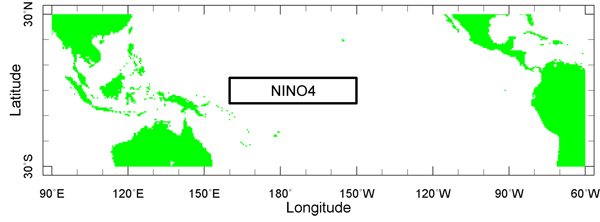
ENSO is monitored by measuring the ocean temperature, also known as sea surface temperature (SST). One place SSTs are measured is NINO4 (Figure 2), a virtual box in the Pacific Ocean to the east of Indonesia. The temperature measured here, called the NINO4 Index, provides a good indicator of different ENSO phases.

What are the different phases of ENSO?
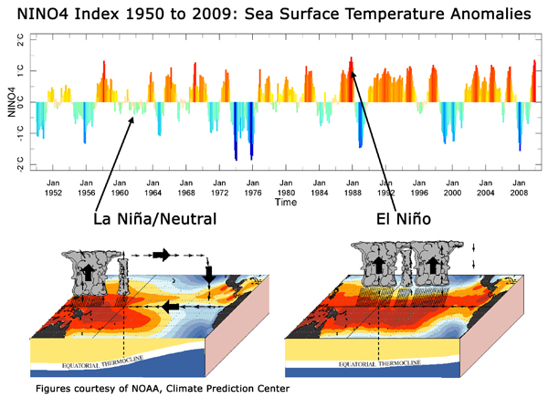
Normal to cooler sea surface temperatures in the tropical Pacific (including in NINO4) cause Neutral or La Niña ENSO phases. Warmer SSTs lead to the ENSO phase called El Niño.
Why does an El Niño cause drought in Indonesia?
During La Niña or Neutral ENSO phases, rain falls over Indonesia and the western Pacific (Figure 1 - top). During the El Niño phase of ENSO much of the rain shifts east, resulting in less rain and drier conditions over Indonesia (Figure 1 - bottom).
What causes ENSO?
ENSO is caused by interactions between the atmosphere and tropical Pacific Ocean. La Niña or Neutral conditions occur when the sea surface temperature is cooler, causing the trade winds to blow strongly and rain to fall over the western Pacific, including over Indonesia. Meanwhile, like a giant bathtub, the ocean adjusts its temperature, and the colder water of the central and eastern Pacific is gradually replaced by the warm water of the western Pacific Ocean. This warming causes El Niño conditions, as the trade winds weaken and the rain shifts east, away from Indonesia. This chain of events continues, and ENSO oscillates back and forth between La Niña and El Niño phases. However, the timing and intensity of these oscillations vary considerably over time. (See Figure 3.)

Can ENSO be predicted?
In the tropical Pacific, ENSO is the most predictable component of the climate system. Sea surface temperatures change slowly, so once a La Niña or El Niño has started it is possible to make seasonal forecasts several months into the future. Scientists at Columbia University were the first to successfully predict an El Niño several months in advance, during the 1986-1987 El Niño event.
Can ENSO prediction help forecast fire risk over Indonesia?
Since El Niño events usually begin in April to June, it is often possible to predict the rainfall over Indonesia during the dry season (June to October for Kalimantan), as well as to estimate when the dry season will end.
In this exercise, we will use the Sea Surface Temperature indices NINO4 data (Reynolds, et al).
