Land Surface and Air Temperature
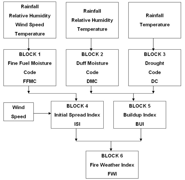
Air temperature is used in the Fire Danger Rating System (FDRS), also called the Fire Weather Index (FWI), to estimate changes in Fine Fuel Moisture Content (FFMC) and, therefore, to estimate changes in vegetation flammability. FDRS is a tool developed in Canada to estimate the risk of fire based on long-term research that related meteorological conditions to a specific type of vegetation (standard pine fuel type composed of jack pine and lodgepole pine). The main goal of creating the FDRS is to obtain a new fire danger index based solely on weather (rain, temperature, relative humidity and wind) that could be used to give uniform results throughout Canada. The FDRS (Figure 16) comprises three fuel moisture codes representing different layers in the forest floor and three fire behavior indices. The Fine Fuel Moisture Code (FFMC) is a numerical rating of the moisture content of surface litter and other cured fine fuels on the forest floor; the Duff Moisture Code (DMC) is a numerical rating of the average moisture content of loosely compacted organic layers of moderate depth in the forest floor; the Drought Code (DC) is a numerical rating of the average moisture content of deep, compact organic layers in the forest floor; the Initial Spread Index (ISI) is a numerical rating of the expected rate of fire spread; the Buildup Index (BUI) is a numerical rating of the total amount of fuel available for combustion; and the Fire Danger Rating System (FDRS) combines the previous indices to represent fire intensity.
This approach has been used in several other locations including countries in South Asia. The following study shows the limitation of this approach, in particular by analyzing the air temperature variation as a factor in the FDRS.
The estimation of air temperature (Ta) is useful for a wide range of applications such as agriculture, climate related diseases and climate change studies. Air temperature is commonly obtained from synoptic measurements in weather stations. In Africa and Asia, the spatial distribution of weather stations is limited, and the dissemination of temperature data is variable, therefore limiting their use for real-time applications. Compensation for this paucity of information may be obtained by using satellite-based methods. However, the derivation of near surface air temperature (Ta) from the land surface temperature (Ts) derived from satellite is far from straightforward.
This includes two steps:
- The derivation of skin surface temperature (Ts) from the thermal infrared (TIR) signal received by the sensor, and
- The estimation of Ta from Ts. Satellite sensors measure a signal that is a combination of the radiant temperature of the land surface and the intervening atmosphere.
The land surface emits radiance differently across the thermal spectrum, and the emitted radiance is affected by the composition of the surface constituents, particularly the spectral emissivity.
There have been numerous methods developed to estimate and account for the effects of surface emissivity and atmospheric effects. The contribution of the atmosphere is taken into account by using a split window technique. This approach uses the fact that the different signals in two thermal bands that are being observed in the same area of the surface are caused by the differential absorption of radiation in the atmosphere. Specific algorithms were developed for AVHRR, MODIS and Meteosat. The split-window algorithm used for MODIS data corrects for emissivity effects by estimating the emissivities in bands 31 and 32 from land cover types.
To estimate Ta from Ts, two approaches may be distinguished according to the time of day. During the night, the retrieval of minimum Ta is simpler as the solar radiation does not affect the thermal infrared signal (Vancutsem et al., 2010).
During the day, the difference between Ts and maximum Ta is mainly controlled by the surface energy balance, which is a complex system dependant on information not easily available, e.g. solar radiation, cloud cover, wind speed, soil moisture and surface roughness (Prince et al., 1998). Therefore, an under-parameterization problem is encountered when estimating air temperature from surface temperature measurements, since the spectral information from the sensors is not able to account for all the major variables.
For this analysis we only use the Ts retrieved during the night from the MODIS sensor 1km spatial resolution (Figure 17) where night Ts is close to minimum air temperature (Vancutsem et al., 2010).
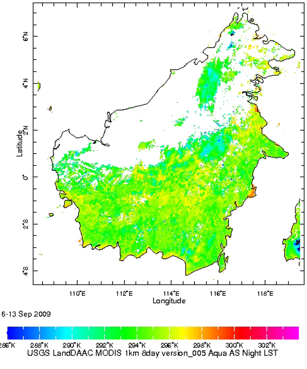
The nighttime Ts, available every 8 days at 1km spatial resolution, corresponds to minimum air temperature.
Figure 18 shows the temporal evolution of minimum air temperature as estimated from MODIS Ts night between Jul 2002 and Apr 2010 on an 8-day basis.
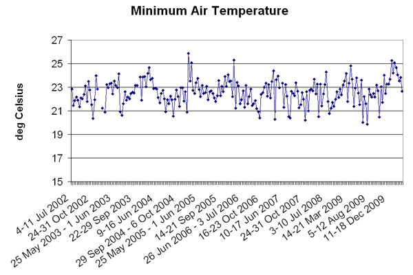
Minimum air temperature is stable around 23C with a range variation reaching 6C (between 20C and 26C). In comparison, Canada experiences temperature range variations reaching up to 30C. Due to its stability, temperature in Kalimantan is, therefore, not a driving factor which contributes to variations of FFMC and, therefore, risk of flammability.